GEOG 1700: Natural Disasters
Tracking Earthquakes and Volcanoes using Google Earth
This signature assignment for GEOG 1700: Natural Disasters included using Google Earth to track earthquakes and identify volcanoes. Below are the earthquakes and volcanoes I chose for this assignment.
Part I: Earthquakes
Earthquakes located at five different tectonic plate boundaries are pictured and described below. The plate boundaries are: transform, oceanic-oceanic convergent, oceanic-continental convergent, continental-continental convergent and divergent boundaries. Information regarding the location, date/time, depth and magnitude are also listed.
Transform Boundary

Magnitude: 4.2
Location: Baja California, Mexico;
32.107 degrees N, 115.301 degrees W
Date: February 29, 2012 Time: 1:27:28 UTC
Depth: 20.1 km (12.5 mi) Tectonic plate boundary: Transform
The area effected by this earthquake is a transform plate boundary. The San Andreas fault is located where two plates are sliding past one another and extends into Baja California. The Pacific Plate moves northward as the North American Plate slides southward.
Oceanic - Oceanic Convergence
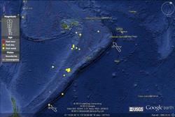
Magnitude: 5.0
Location: Fiji Island Region;
18.005 degrees S, 178.493 degrees W
Date: February 26, 2012 Time: 5:08:12 UTC
Depth: 587 km ( 364.8 mi) Tectonic plate boundary: Oceanic-oceanic convergent
This area is complex because there are multiple tectonic plates colliding. The Australian plate and Pacific plate collide and create a subduction zone called the Somoan Trench. This region records many earthquakes.
Oceanic - Continental Convergence

Magnitude: 5.3
Location: Northern Columbia;
6.667 degrees N, 72.964 degrees W
Date: February 23, 2012 Time: 13:43:17 UTC
Depth: 169.1 km (105.1 mi) Tectonic plate boundary: Oceanic-continental convergent
The Nazca plate in the Pacific Ocean is moving eastward to collide with the South American plate, which is moving westward. The collision of the two plates created the earthquake seen here. This tectonic boundary type also produces many explosive composite volcanoes.
Continental - Continental Convergence

Magnitude: 4.4
Location: Nepal;
29.802 degrees N, 81.227 degrees E
Date: February 26, 2012 Time: 23:08:48 UTC
Depth: 35.1 km (21.8 mi) Tectonic plate boundary: Continental-continental convergence
In this tectonic boundary, the Indian plate is moving northward and crashing into the Eurasian plate. This particular boundary resulted in the Himalayan Mountains. The upward thrust of materials as the mountain range is created during continental collision causes many earthquakes.
Divergent Boundary

Magnitude: 5.3
Location: Southern Mid-Atlantic Ridge
17.726 degrees S, 13.136 degrees W
Date: February 23, 2012 Time: 5:08:12 UTC
Depth: 10 km (6.2 mi) Tectonic plate boundary: Divergent
The Mid-Atlantic Ridge separates the North American plate from the Eurasian plate and the African plate from the South American plate in the Atlantic Ocean. Magma from the mantle fills the trench that is created as the plates diverge, forming the longest mountain range in the world.
Part II: Volcanoes
Stratovolcano - Volcan de Agua

The stratovolcano, or composite volcano, is typically found at an oceanic-continental boundary. They have viscous magma with a tendency for explosion. The magma can be made of basalts, andesites and rhyolites. The volcano pictured is Volcan de Agua, located in Guatemala, near the city of Antigua. It has been inactive since the sixteenth century. Although inactive, the volcano has the potential to produce mudflows and debris flows called lahar. The volcano was produced due to the collision of the Pacific plate and the South American plate.
Shield Volcano - Mauna Kea, Hawaii

Shield volcanoes tend to be the largest volcanoes in the world due to the fact that their bases are on the ocean floor. The shield volcano is found over volcanic hotspots and have very low viscosity basaltic magma. The Hawaiian Islands are examples of hot spot islands created as the tectonic plate moves over a volcanic hot spot, in turn creating an island chain. Mauna Kea is a shield volcano that has formed as molten lava slowly rises from the mantle and flows down the sides of the volcano. Mauna Kea is the heighest peak in the state of Hawaii. One interesting side note: Mauna Kea's summit is an ideal location for astronomical observatories due to it's height and dry climate.
Cinder Cone - Sunset Crater, Arizona

Cinder cones are found at oceanic-continental boundaries. They are comprised of tephra that has accumulated around a volcanic vent. Many cinder cones are found around the base of stratovolcanoes and shield volcanoes. Sunset Crater cinder cone was formed approximately 1000 years ago just north of Flagstaff, Arizona.
Caldera - Isla Tortuga

This caldera is found at a divergent boundary in the East Pacific Rise, a mid-oceanic ridge. Materials from the volcano exploded violently and created the crater-like caldera on the top of the volcano. Calderas are formed when materials build up in the lava tubes of volcanoes, blocking the escape of gasses. The pressure from the gas build-up can create an explosion followed by the collapse of the magma chamber below. This produces the depression at the top of the volcano called a caldera.
Seismic activity correlates directly with tectonic plate boundaries. As the material in the mantle shifts through the process of convection, the overlying crust is moved along with it. Transform boundaries, like the San Andres Fault, illustrate this well. As the plates move past each other, they build up stress because they cannot slide past one another in a smooth fashion. When the stress reaches the breaking point, the plates jolt past each other and cause earthquakes. When two plates converge, one plate may dive beneath the other, creating areas of high seismic activity as well.
The location of volcanoes also correlates directly with tectonic plate boundaries. At divergent boundaries, the tectonic plates are moving away from each other, allowing the molten magma to rise and fill the rift. When a ridge is seen on land, such as in Iceland, a shield volcano can form. Highly explosive composite volcanoes are typically seen at convergent plate boundaries. The greatest evidence of plate tectonics can be seen at the ‘Ring of Fire’, where the Pacific plate converges with multiple tectonic plates forming a continental ‘ring’ around the Pacific Ocean when viewed from space.
This assignment was not only an eye-opener but also quite interesting. I was unaware of the distribution of earthquake-prone areas and volcanoes in relation to plate tectonics. Oceanic-continental subduction zone boundaries seem to create the most earthquake and volcanic activity (when compared to other boundary types). It is not often realized that plate tectonics create zones of natural resources like oil, gas, and minerals that we are highly dependent on to produce the soil for growing crops. Without plate tectonics our planet would quickly run out of certain minerals which, in turn, would have a very detrimental effect on living organisms.
When I previously thought of volcanoes, the picture I conjured was the typical stratovolcano with pyroclastic eruptions that is portrayed in the media and films. I paid little attention to the hot spots, shield volcanoes, cinder cones and calderas that also demonstrate volcanic activity. I knew that Yellowstone National Park was a hotspot that has historically erupted to produce a caldera. The point that I hadn't thought over was the impact of the processes taking place and the potential impact another eruption at that location could have.
This assignment has changed my view on worldwide natural disasters. Population density tends to be higher in areas that are prone to volcanic and seismic activity but this is in part due to the availability of natural resources. Natural resources are limited and our increasing population is putting a strain on the known reservoirs. This leaves exploration and settlement into more dangerous locations our only option.
